抢先看大蒙特利尔区最新公共交通地图
发布时间: 2023-07-12 14:08
| 阅读: 14050
| 点赞: 36
| 留言: 6

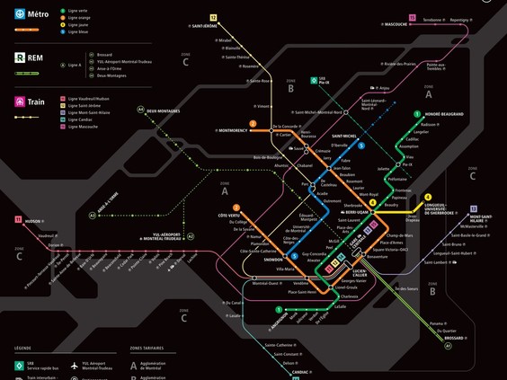
蒙特利尔的公共交通网络正在产生美好变化,大都会地区交通管理局(ARTM)创建的一张新地图反映了这一点。
该最新地图包括了四种主要交通方式:地铁、通勤列车、新轻轨系统 (REM) 和快速巴士服务。
轻轨是迄今为止最重要的新增指标,即将开通连接蒙特利尔和南岸的线路以鲜艳的绿色突出显示。

未来的轻轨线路——将通往机场、西岛和北岸——在新地图中也被勾画出来,但以虚线的形式表明其正在进行的状态。因此,中央车站(Gatre-Centrale)至至Brossard的轻轨南岸支线将于7月31日起通车,便以绿色实线显示出来。
请 点击这里 查看地图的高质量版本。
特别声明:本文及配图均为用户上传或者转载,本文仅代表作者个人观点和立场,不代表平台观点。其原创性以及文中陈述文字和内容未经本站证实,
对本文以及其中全部或者部分内容、文字的真实性、完整性、及时性本平台不作任何保证或承诺,请读者仅作参考,
并请自行核实相关内容。如发现稿件侵权,或作者不愿在本平台发布文章,请版权拥有者通知本平台处理。
微头条提供网站服务和存储空间支持。
Copyright Disclaimer: The copyright of contents (including texts, images, videos and audios) posted above belong to the User who shared or the third-party website which the User shared from. If you found your copyright have been infringed, please send a DMCA takedown notice to [email protected] Web services and Hosting provided by Microheadline.
Copyright Disclaimer: The copyright of contents (including texts, images, videos and audios) posted above belong to the User who shared or the third-party website which the User shared from. If you found your copyright have been infringed, please send a DMCA takedown notice to [email protected] Web services and Hosting provided by Microheadline.